natural hazards
Type of resources
Keywords
Publication year
Service types
Topics
-
"History provides a limited picture of what can happen from tropical cyclones (TCs). Take the example of Port Hedland or Townsville, with limited numbers of close TC impacts, especially in recent decades, where many communities have gone through rapid growth. How could emergency services in these towns prepare adequately for a major TC strike with no recent experience? How do they know if they have sufficient resources? Will they need to call in resources from other regions or further afield? In this presentation, we will discuss two parts of this problem – developing plausible scenarios of TCs for use in exercises and then evaluating the impacts of a selection of these events to guide planning and response actions for emergency services. GA’s Tropical Cyclone Hazard Assessment (TCHA) provides the backbone of impact scenario modelling – a stochastic catalogue of 10,000 years of plausible TC events that users can delve into. We connect the scenarios to our extensive built environment data collection and the corresponding vulnerability modelling capability to deliver tangible information on the impacts that as-yet unseen events could deliver to communities around our northern coastline.
-
Knowledge of the nature of buildings within business precincts is fundamental to a broad range of decision making processes, including planning, emergency management and the mitigation of the impact of natural hazards. To support these activities, Geoscience Australia has developed a building information system called the National Exposure Information System (NEXIS) which provides information on buildings across Australia. Most of the building level information in NEXIS is statistically derived, but efforts are being made to include more detailed information on the nature of individual buildings, particularly in business districts. This is being achieved in Adelaide through field survey work.
-
A framework is presented for the probabilistic modelling of non-stationary coastal storm event sequences, and is applied to a study site on the East Australian Coast. Storm waves at this site are found to exhibit non-stationarities related to ENSO and seasonality. The impact of ENSO is most prominent for storm wave direction, long term MSL and the rate of storms, while seasonal non-stationarity is more ubiquitous, affecting the latter variables as well as storm wave height, duration, period and surge. The probabilistic framework herein separates the modelling of ENSO and seasonal non-stationarity in the storm wave properties from the modelling of their marginal distributions, using copulas. This separation enables non-stationarities to be straightforwardly modelled in all storm wave variables, irrespective of whether parametric or non-parametric techniques are used to model their marginal distributions. Storm wave direction and steepness are modelled with non-parametric distributions whereas storm wave height, duration and surge are modelled parametrically using extreme-value mixture distributions. The advantage of the mixture distributions, compared with the standard extreme value distribution for peaks-over-threshold data (Generalized Pareto), is that the statistical threshold becomes a model parameter instead of being fixed, and so uncertainties in the threshold can be straightforwardly integrated into the analysis. Uncertainties in the model predictions are quantified using a mixture of parametric percentile bootstrap and Bayesian techniques. Percentile bootstrap confidence intervals are shown to non-conservatively underestimate uncertainties in the extremes (e.g. 1% annual exceedance probability wave heights), both in an idealized setting and in our application. The Bayesian approach is applied to the extreme value models to remedy this shortcoming. The modelling framework is applicable to any site where multivariate storm wave properties and timings are affected by seasonal, climatic and long-term non-stationarities. This paper is published in Coastal Engineering, see https://doi.org/10.1016/j.coastaleng.2017.06.005
-
<div>This document steps teachers and students through accessing and using satellite data on the Digital Earth Australia (DEA) Portal, with a particular focus on bushfires and flood events. The document is intended to be followed with the DEA portal open so teachers and students can explore the data using the links provided in the guide. The document also provides brief background information on how spectral satellites operate and how various bands of the electromagnetic spectrum can deliver useful data.</div>
-
<div>Students can access and analyse real world earthquake data using online portals created by Geoscience Australia (GA) (Geoscience Australia data portal and Earthquakes@GA). The document provides background information for teachers about earthquakes and the online portals, as well as two student inquiry activities. Each activity includes instructions on how to access and use the relevant portal as well as questions that prompt students to find, record, and interpret the data. An Excel table is provided to accompany one of the activities.</div><div><br></div><div>The activities are suitable for use with secondary to senior secondary science and geography students. The topics covered in these activities include: earthquakes, plate tectonics and natural hazards.</div><div><br></div><div>The print version has lines provided for written answers, the accessible version is intended for digital responses. </div>
-
Geoscience Australia, together with contributors from the wider Australian seismology community, have produced a draft National Seismic Hazard Assessment (NSHA18), recommended for inclusion in the 2018 update of Standards Australia’s Structural design actions, part 4: Earthquake actions in Australia, AS1170.4–2007 (Standards Australia, 2007). This Standard is prepared by Subcommittee BD-006-11, General Design Requirements and Loading on Structures of Standards Australia. The provisional seismic hazard values presented in this report have been submitted to comply with Standards Australia’s public comment and publication timelines. This report provides a brief overview of provisional mean peak ground acceleration values (equivalent to the seismic hazard factor Z in AS1170.4) and the approaches used. The hazard values are calculated on rock sites (AS1170.4 Site Class Be) for a probability of exceedance of 10% in 50 years (0.0021 per annum). Continued refinement of these values will occur throughout, and in response to, the first public comment period. While only minor changes are expected, the final NSHA18 will be completed prior to Standard Australia’s planned second public comment period (likely in late 2017). The NSHA18 update yields many important advances on its predecessors, including: • calculation in a full probabilistic framework (e.g., Cornell, 1968) using the Global Earthquake Model Foundation’s OpenQuake-engine (Pagani et al., 2014); • consistent expression of earthquake magnitudes in terms of moment magnitude, MW; • inclusion of epistemic uncertainty through the use of third-party source models contributed by the Australian seismology community; • inclusion of epistemic uncertainty on magnitude-frequency distributions; • inclusion of a national fault-source model based on the Australian Neotectonic Features database (Clark et al., 2012; Clark et al., 2016); • inclusion of epistemic uncertainty on fault-slip-model magnitude-frequency distributions and earthquake clustering; and • use of modern ground-motion models.
-
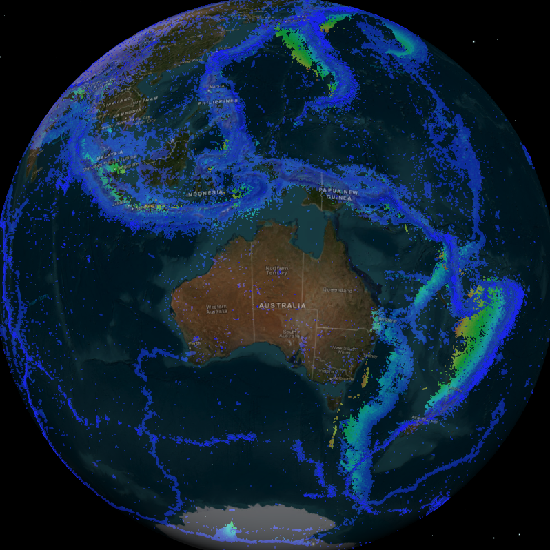
The service contains the 2013 Earthquake Hazard map, as a raster and contours. This map shows the peak ground acceleration (response spectral period of 0.01 seconds) on rock expected for a 500 year return period, in units of g, evaluated for the geometric mean of the horizontal components. The map is the closest in return period and response spectral period to the current earthquake hazard map in the Australian Standard AS1170.4-2007.
-
The service contains the 2013 Earthquake Hazard map, as a raster and contours. This map shows the peak ground acceleration (response spectral period of 0.01 seconds) on rock expected for a 500 year return period, in units of g, evaluated for the geometric mean of the horizontal components. The map is the closest in return period and response spectral period to the current earthquake hazard map in the Australian Standard AS1170.4-2007
-
Knowledge of the nature of buildings within CBD areas is fundamental to a broad range of decision making processes, including planning, emergency management and the mitigation of the impact of natural hazards. To support these activities, Geoscience Australia has developed a building information system called the National Exposure Information System (NEXIS) which provides information on buildings across Australia. Most of the building level information in NEXIS is statistically derived, but efforts are being made to include more detailed information on the nature of individual buildings, particularly in CBD areas. This is being achieved in Brisbane through field survey work.